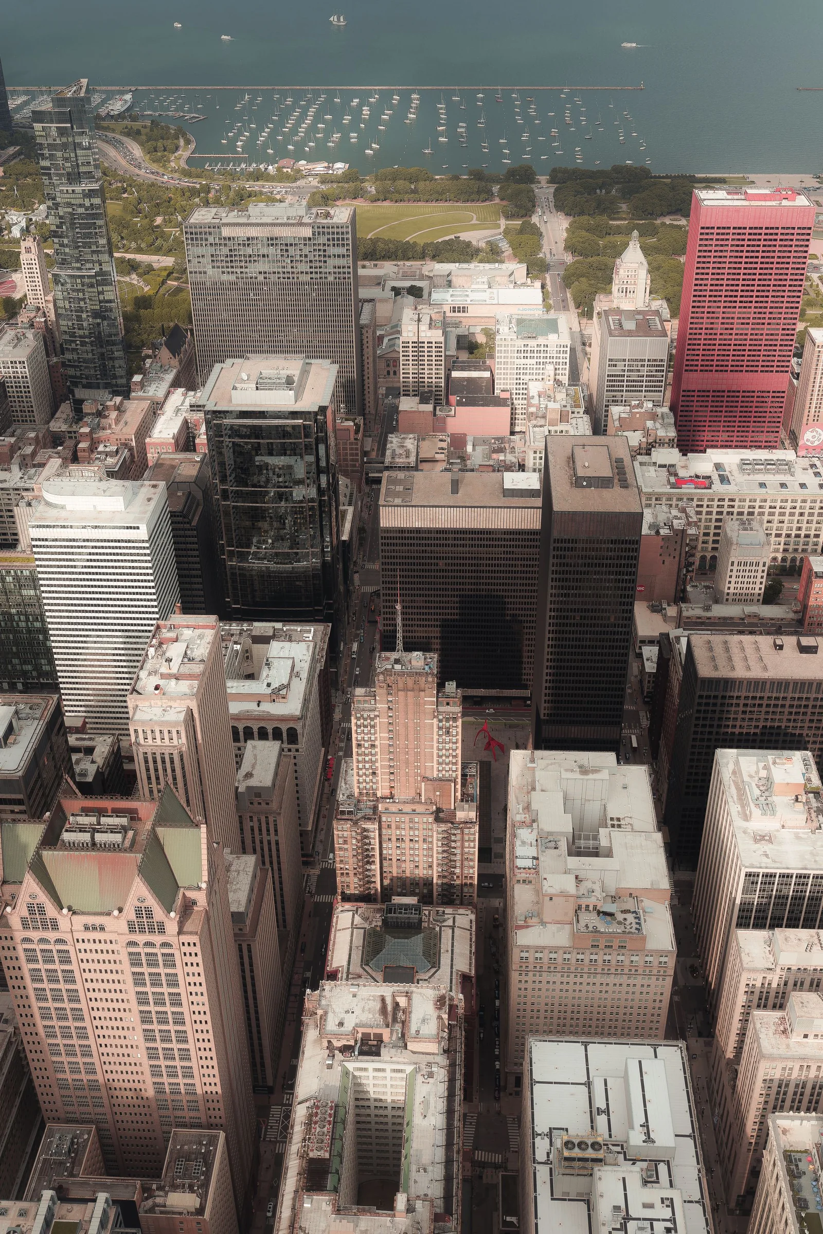
A useful Chicago drone photography quote describes a finished media product at a verified address. It is not simply an hourly rate multiplied by a guess at flight time. A commercial broker may need photographs that explain access, parking, transit, and the relationship between a property and the Loop. A contractor may need fixed monthly views that reveal façade, roof, logistics, and site progress. A hospitality team may need a short film connecting architecture with the river, lakefront, or neighborhood. An agency may want an unmistakably Chicago establishing sequence without discovering on the shoot morning that the preferred roof, park, sidewalk, or airspace cannot be used.
The address changes the work. A Streeterville tower, Fulton Market redevelopment, West Loop office, South Side industrial property, suburban logistics campus, and North Shore venue do not share the same airspace, property control, public-way activity, wind exposure, or visual priorities. O’Hare and Midway are only the most visible parts of a dense aviation environment that also includes heliports, hospital traffic, temporary flight restrictions, and several regional airports. Lake Michigan can influence wind, cloud, haze, and temperature close to the shore while conditions farther inland look different.
This guide helps owners, marketers, brokers, contractors, producers, venue teams, and procurement staff request comparable proposals. It does not invent a universal Chicago rate card. Instead, it shows where real preparation and labor enter the price, which responsibilities belong in writing, and how to recognize a bid that is inexpensive only because essential work is missing. For an address-specific review, use the Chicago project quote form and include the location, intended use, preferred dates, and required files.
Define the finished media before asking for a price
Begin with the decision your audience must make
The first sentence of a production brief should explain what the finished media needs to accomplish. A leasing prospect may need to understand a building’s mass, entrances, parking, transit context, roof amenities, neighborhood texture, and proximity to an expressway. A construction stakeholder may need to compare excavation, concrete, steel, enclosure, sitework, and staging changes across visits. A hotel buyer may need to picture arrival, outdoor spaces, views, and access to recognizable city features. These are communication requirements, not merely attractive shots.
“We need a few aerials” leaves almost every price variable undefined. A stronger request might specify twelve retouched photographs, eight organized 4K video selects, and one thirty-second web edit showing the primary entrance, building elevations, site context, access, and evening lighting. Add the required horizontal and vertical formats, where the work will run, the delivery deadline, and who approves it. Providers can then price the same product.
Purpose also determines what can be removed. A dramatic skyline view may establish Chicago yet do little to explain a loading court. A fast orbit can feel energetic but crop poorly for vertical social media. A long river reveal can support a destination film but waste field time on a roof record. Clear priorities allow an operator to design an efficient sequence rather than pricing every beautiful possibility.
Separate photographs, video selects, source clips, and completed edits
Chicago architecture campaigns are easier to price when the brief names the visual states instead of only the media type. A tower may need a clean elevation, a river-context reveal, a transit-and-entry view, an amenity relationship, and an evening identity frame. For each state, specify whether the buyer expects a retouched photograph, a graded motion select, or a finished sequence. Raw capture is production material, not an automatic substitute for curated files: it can include exposure tests, repeated paths, interrupted moves, and shots rejected for traffic or composition. A completed edit adds an argument about the property through pacing, titles, sound, music rights, graphics, and deliberate exports.
Chicago’s vertical architecture makes crop planning a field decision. A wide river approach can communicate two neighboring towers beautifully yet leave neither building legible in a vertical advertisement. A portrait composition may favor a façade but eliminate the lake, rail, or street relationship that makes the location valuable. If the campaign needs web banners, leasing decks, square carousels, and vertical reels, identify which fact each format must retain. The operator can then capture parallel paths, hold additional negative space, or isolate architectural layers rather than asking post-production to rescue a composition designed for another channel.
Build a deliverable matrix
Build one row around each audience decision: recognize the address, understand access, compare the skyline position, imagine the tenant experience, or verify a documented exterior condition. Add the view, light state, file type, orientation, finish, channel, due date, and approving stakeholder. Flag any property-line overlay, transit label, tenant mark, licensed track, narration, or clean master. This matrix prevents a count of “twenty images” from hiding the fact that procurement, leasing, architecture, and social teams expect four different products.
Organization should mirror Chicago’s building logic. A recurring Chicago construction documentation program can index files by address, elevation, level band, river or street interface, date, and milestone so a stakeholder can retrieve the right comparison without opening every folder. Marketing work may separate evergreen architecture, seasonal context, people-dependent scenes, clean plates, and campaign derivatives. When two proposals both promise photos and video, ask whether either one delivers this usable visual library or merely transfers a mixed folder after landing.
Distinguish visual documentation from specialized analysis
Standard aerial media can reveal context, make exterior conditions visible, support stakeholder discussion, and preserve a dated visual record. It does not by itself answer whether a façade is safe, a roof assembly has failed, a boundary is legally correct, or a measured model meets survey or engineering requirements. Those conclusions belong to appropriately qualified professionals using fit-for-purpose methods. If a team requests thermal capture, mapping, measurement, or condition analysis, the quote should separate acquisition, control and calibration, data processing, interpretation, and professional responsibility rather than collapsing them into “drone inspection.”
For a facility, roof, utility corridor, or solar asset, the Chicago industrial drone documentation service should begin with the questions a qualified inspector or asset owner needs documented. The capture team can plan orientations, references, coverage, file lineage, and secure delivery around that review. The qualified specialist remains responsible for diagnosis and regulated conclusions. Price acquisition and interpretation as different workstreams; a visually impressive orbit that cannot be traced to a component or reviewed at useful detail is not a lower-cost version of a technical record.
Price the Chicago location and every approval layer
Use exact coordinates for airspace review
Treat coordinates as a creative input, not an administrative detail. Commercial small-drone work generally sits within the FAA’s Part 107 framework, and eligible controlled-airspace requests may use LAANC. The authorized altitude and footprint can determine whether a proposed river reveal, tower orbit, or skyline separation is possible. The same approval says nothing about who controls the rooftop, loading court, riverwalk staging area, park, venue campus, or neighboring parcel. A Chicago estimate should therefore pair an address-level airspace check with a ground-control map before promising the hero move.
Chicago’s aviation picture is not simply “near O’Hare” or “away from Midway.” Exact coordinates, requested altitude, operating footprint, date, nearby heliports, hospital routes, regional airports, temporary restrictions, and other aircraft activity can matter. A provider must check the proposed launch point and work area in current FAA sources. “We flew nearby before” is not a current authorization.
The FAA’s Part 107 overview also makes the remote pilot responsible for operating limitations, visual line of sight, aircraft condition, visibility, and rules involving people and moving vehicles. Translate those constraints into the shot plan. A narrow operating area may favor layered push-ins over a wide orbit; heavy pedestrian movement may shift exterior capture to an earlier window; a limited ceiling may make street-to-roof parallax more useful than a generic high view. This translation is part of production design and should appear in a credible price.
Identify who controls the ground
Draw a ground-access topology for the desired sequence. Mark the crew entrance, loading point, equipment staging, launch and recovery area, roof route, elevator reservation, security post, public-way edge, river or rail interface, and any place where pedestrians or vehicles affect the operation. Then attach a controlling party to every node. In Chicago, the owner, manager, general contractor, tenant, park authority, venue, or public agency may control different pieces of what appears to be one location. Unassigned nodes become waiting time, a lost view, or a permit problem.
Chicago’s municipal code defines a film production event around exclusive public-way use, requested City services, closures, staging, and certain regulated production activity. The official Chicago film-production permit provision separates ordinary unobstructive filming from activity that needs a City Services Request and CDOT Film Production Permit. Do not assume a quiet sidewalk or curb lane can become a drone base because a crew plans to remain only briefly.
Parks are controlled separately. The Chicago Park District states that commercial and web-based filming, wedding photography, documentaries, and other listed uses require a filming and photography permit. Its broader permit guidance also identifies flying machines, including drones, among activities that can require special-event review. A lakefront image request may therefore involve FAA airspace, Park District ground permission, property access, crowd planning, and the actual feasibility of maintaining the required operation.
Ask five different permission questions
A complete scope distinguishes FAA airspace authorization, approval from the launch-property controller, municipal or park permits, venue or facility rules, and releases or clearances for the finished media. Different organizations answer those questions. Approval from one does not replace another.
For example, a riverfront project may have workable airspace but no authorized ground position. A privately controlled rooftop may solve access while the requested flight area remains constrained. A Chicago film permit can regulate crew use of a public way without promising the FAA will approve the proposed altitude. Price and schedule should follow the entire matrix.
Treat airports, rail, bridges, parks, and event campuses as special sites
Airport, rail, transit, bridge, stadium, utility, government, and event properties may have security and access controls beyond ordinary owner permission. The Chicago Department of Aviation states that all commercial filming on O’Hare and Midway property requires written CDA permission and describes a process that can include advance application, technical scouting, insurance, and escorts. That policy is about property and facility access; it does not replace FAA authorization.
Likewise, permission from a broker or tenant does not automatically provide access to railroad land, a CTA facility, a bridge, a stadium campus, Navy Pier, McCormick Place, or a neighboring roof. If the desired view depends on one of those locations, name the controlling entity, contact path, insurance requirement, and fallback position before fixing the shoot date.
Multi-location projects repeat more work than driving
Travel between the Loop, River North, West Loop, South Loop, O’Hare corridor, Oak Brook, Schaumburg, Naperville, North Shore, and industrial submarkets is only one part of a multi-site price. Traffic, parking, loading rules, security, elevator reservations, roof access, gated facilities, and different municipalities add schedule risk. Each address still needs condition review, access confirmation, obstacle and sight-line checks, crew briefing, aircraft setup, exposure decisions, essential capture, file verification, and breakdown.
Light windows may conflict. A river-facing façade can look best in one sun direction while a western elevation improves later. A venue may want empty exterior views before attendees arrive. A contractor may suspend capture during a crane pick. A lakefront location may meet the creative threshold while an inland address has different haze or cloud. List all addresses before asking for a combined-day price.
Design crew and timing around the urban operation
Assign roles to specific risks
A prepared exterior assignment on controlled private property may be possible with one remote pilot and a reliable site contact. A downtown roof, active high-rise project, industrial yard, crowded venue, narrow river corridor, or moving ground production may justify a visual observer, site liaison, producer, or separate ground-camera operator. Each added role should solve a named problem.
Price the client’s decision capacity as carefully as the crew. One person may be authorized to open the roof but unable to approve a tenant logo; another may manage security but not move a contractor vehicle; the agency producer may approve framing but not a building-management restriction. Name the access lead, operations lead, and creative approver, plus the deadline for each decision. A shoot can lose its best light while everyone waits for a well-intentioned property contact who was never given the authority the brief assumed.
Event work needs especially clear timing. The Chicago concert and event drone service must integrate with venue management, security, audience movement, traffic, talent, and the run of show. Exterior establishing views before attendance builds may be feasible while a requested pass at peak ingress describes a very different ground environment. Price must follow the requested moment, not the general event address.
Treat lake influence, tower wind, visibility, and cold as production inputs
Chicago weather affects more than whether an aircraft can take off. Wind can accelerate near tower corners and above a protected street canyon. Conditions at roof level can differ from those at the entrance. Lake-influenced clouds, haze, mist, temperature changes, and onshore flow can affect a lakeside location while a western suburb looks clearer. Winter adds cold batteries, shorter daylight, snow, ice, salt residue, and difficult roof access.
The National Weather Service publishes current observations and Chicago’s 1991–2020 climate normals, but a climate table does not approve a flight. A Part 107 pilot must apply current weather, operating rules, aircraft limits, site conditions, and the specific visual requirement. A generic app’s single wind number cannot describe turbulence around a parapet or the visibility needed for a long skyline view.
Weather also changes the desired image. Overcast light can be excellent for façade detail and progress records because it lowers contrast. Wet pavement can add reflection to a campaign. A hospitality or real-estate assignment promising blue lake color, sunset, an open skyline, autumn canopy, or a clean snowy scene needs a different threshold from a documentary roof record.
Write a two-level weather plan
Level one lists essential deliverables: site context, principal elevations, access, fixed progress views, roof zones, or a venue exterior. Level two lists conditions-dependent upgrades: crisp long-distance skyline separation, warm sunset, visible blue water, dry event grounds, fall color, or fresh snow.
Capture level one whenever the operation and image standard are safe and acceptable. Pursue level two only within the agreed threshold. The proposal should name the forecast review time, final safety authority, included weather date, rescheduling terms, access costs, and what happens when only the essential list is feasible.
Plan streets, water, people, vehicles, and rail before arrival
The client should never infer that “the drone will be high” solves the ground plan. Operations over people and moving vehicles have specific federal requirements and operational implications. A public gathering, Riverwalk crowd, busy arterial, active rail line, vessel movement, construction pick, or event queue can reshape the usable path and time.
A practical alternative may be to work from owner-controlled property at a quieter time, use a lower or more oblique composition, capture before opening, or combine aerial context with ground photography. These are production design decisions. They should be agreed before the campaign depends on one impossible hero move.
Include post-production, licensing, and review in the comparison
File handling begins before editing
Professional post-production starts with verified transfer, organized storage, and a reviewable selection process. Large 4K or higher-resolution files take time to copy, verify, back up, label, and upload. A recurring program may need consistent naming and separation by date, property, elevation, view, or work package. A campaign may need a contact sheet or review gallery before final retouching.
Ask how long the provider retains camera files and deliverables. Define whether the client receives camera originals, only selected footage, or only final exports. The words “all footage” are ambiguous unless the agreement describes format, organization, technical finish, transfer method, and retention.
Match image finishing to the use
Photography finishing may include exposure and color correction, perspective control, removal of temporary sensor spots, selective cleanup, stitching, supplied annotations, and crops. Video finishing may include stabilization, color correction, sequencing, sound design, licensed music, titles, captions, speed changes, maps, logos, and multiple aspect ratios. Some edits are creative choices; others correct technical variations across changing light.
Avoid assuming that heavy manipulation is included. Removing vehicles, signs, cranes, wires, roof equipment, neighboring structures, or people can be substantial compositing work and may create a misleading representation. If a real-estate or construction use requires documentary accuracy, agree on what may and may not be altered.
State licensing and releases in plain language
The agreement should say who may use the files, where, for how long, in which media, and whether paid advertising, broadcast, resale, transfer to tenants or partners, or third-party syndication is included. A local leasing campaign, a national advertising buy, and unrestricted source-footage transfer are different uses.
Property permission is not automatically a trademark, artwork, talent, or privacy release. Chicago’s skyline, architecture, public art, venue signage, and crowds can introduce separate clearance questions depending on the production and distribution. The client or agency should identify who handles those decisions.
Define revisions, rush work, and change control
Completed edits should include a stated number of consolidated review rounds. “Unlimited revisions” often hides an undefined schedule. Ask who combines stakeholder notes, how quickly feedback is due, and which changes count as a new scope. Recutting for a new campaign, replacing music after approval, creating new aspect ratios, or changing the story after capture can require additional work.
Rush delivery compresses backup, selection, editing, review, and quality control. It may also require a dedicated editor or overtime. A fair comparison asks each provider to price the same deadline and review process rather than comparing one normal schedule with one emergency schedule.
Compare proposals by responsibility, not by the bottom line
Use a line-by-line bid table
Place the proposals into common rows: address and operating area; airspace review; property and permit coordination; access assumptions; crew roles; field window; weather plan; still deliverables; video deliverables; post-production; licensing; revisions; delivery; retention; travel; parking; rescheduling; exclusions; and specialized services. Blank cells reveal more than a low total.
Then test whether the provider has priced the actual Chicago conditions. Does the scope rely on an unconfirmed public launch point? Does it promise a lakefront or downtown view without explaining ground control? Does it price a single pilot while expecting the client to manage roof access, security, traffic, and observation? Does it promise “raw footage” without saying what will be organized or color prepared?
Watch for cheap bids that transfer risk to the client
Common warning signs include no exact location review, no distinction between FAA and property permission, no weather or rescheduling clause, undefined file counts, ambiguous rights, missing insurance discussion, unlimited edits, and a schedule that assumes uninterrupted access. A provider can omit these items and appear cheaper because the client has unknowingly accepted the responsibility.
A higher quote is not automatically better. Every added crew member, permit allowance, edit, deliverable, and contingency should solve a defined need. The strongest proposal is the smallest complete plan that can lawfully and reliably deliver the intended outcome.
Send a complete Chicago quote brief
Provide exact addresses or coordinates; intended use and audience; required still and video files; aspect ratios; deadline; desired light or season; must-have views; property contacts; known roof, parking, security, or venue restrictions; expected people and vehicle activity; editing and branding requirements; licensing needs; and weather flexibility. Mark confirmed information separately from assumptions.
For property marketing, the Chicago real-estate drone service can help translate the brief into a site-specific shot plan. For a wedding or engagement, use the Chicago wedding and engagement service and include the venue’s written drone policy, ceremony timing, and alternate exterior window. A complete brief produces a more accurate quote and a much more useful final library.
Chicago drone photography and video pricing becomes understandable when the deliverable, address, approvals, operating plan, weather threshold, post-production, and rights are defined. Compare those responsibilities first. The total then represents a real production plan rather than a hopeful estimate.